A Provisional Assessment of Environmental Consequences in the Balkans of the operation “Allied Force”
by
Zerefos, C., Melas D., Rapsomanikis S., Alexandropoulou A.
2. Dates of importance as to their environmental effects. during the period from 24/3/99 to 8/6/99.
Wartime environmental damage is as old as the Bible. In Deuteronomy (20:19 20) it is stated that “… the trees in the battle field are not men that you should besiege them … “ and in the Tabari, Exegesis of the Qur’an it is advised “not to cut down trees and not to kill animals in the enemy territory …” inspite the religious tenets on war and the environment, addressing excessive environmental damage resulting from armed conflict has always been problematical and it looks as if greening of warfare is an extremely diffucult issue (Austin and Bruch, 1998).
Toward the end of the gulf war Iraqi troops have set hundred of oil wells on fire which resulted to 4.6 million barrels of oil burning daily and to severe pollution episodes in this part of the world. Airborne aerosols reduced solar radiation by about 75% in the Persian Gulf (Hobbs and Radke1992). Their long-range transport in the free troposphere took them as far as to Hawaii (Bodheine et al, 1992). Detrimental environmental effects resulted not only from air pollution but also from the coverage with oil of hundreds of Km of the western coastline of the Persian Gulf with destructive consequences to the coral reefs and local ecosystems.
Airborne pollution from the Kuwait oil fires was detected at large distances from the source. For example, one thousand Km from Kuwait, ozone concentration in the plume exceeded background levels by about 50 ppbv and significant smoke levels were detected (Johnson et al., 1991). A WMO assessment (WMO, 1992) concluded that regional ozone levels at ground level were not elevated substantially and population was not impacted. The report concluded that observed air pollution levels in the desert and at populated areas (in the desert) were comparable to those in industrial areas in the US, Europe and Japan. Transboundary transport in the Balkan region can be responsible for altering even the seasonal pattern of air pollutants (Zerefos et al., 1998).
More recently during the crisis in Kosovo, several reports provided independent assessments of the environmental impact of the military activities during the operation “Allied Force”. These reports include those from the EU, FOCUS and UNEP. There are several other local reports on the same issue, notably a special issue of Chimika Chronika (June, 1999) the official Journal of the Hellenic Society of Chemists, the report to the Ministry of the Environment of Greece by Rapsomanikis et al. (May, 1999), the Report of the Republic of Serbia (July, 1999), BPU (1999) and Liolios (1999).
Preliminary findings from these reports on environmental consequences of the Kosovo conflict can be summarized as follows:
Air: air pollutants at high concentrations including toxic substances (soot, phosgene) or even carcinogenic compounds (VCM, PCBs, possibly DU) were released in the atmosphere from destroyed industrial, military and other facilities.
Water: The water pollution from oil spills and a variety of chemicals (PCBs, VCM, EDC, HCl, HF, heavy metals and many others) will last for many years.
Soil: The pollution near the industrial plants destroyed is significant.
Transboundary: The regions most affected are the neighboring countries, particularly those on the river Danube, downstream from FRY. According to the EU report, future risks are of long-term and refer mostly to Yugoslavia. The effects on humans and the ecosystems of the observed acid rain and the transboundary transport of toxic substances in Romania and other neighboring countries can not be estimated due to lack of reliable regional measurements in the area except for a few cases cited before.
The present work focuses on airborne pollution, at selected dates during the 77 days of the operation allied force. It provides a review of reported measurements by scientists involved in the before mentioned reports.
2. Dates of importance as to their environmental effects during the period from 24/3/99 to 8/6/99.
During the 77-day period of air-strike, a large number of industrial and military facilities have been destroyed (Vukmirovic, 1999). Of those facilities the most notable and of importance as to their effects in the environment, are summarized in Table I (see Appendix). The targeted installations are listed by date.
As can be seen from Table I, the most “severe” environmental episodes in the area are expected to result from emissions which took place in the first and third weeks of April (4-7/4 and 12-19/4). This is because during the 3-day period 4-7 April targets of oil storage, refineries and other plants were hit at a large number of cities notably: Sombor, Novi Sad, Pancevo, Smederevo, Beograd, Novi Beograd, Bogutovac, NIS, Pristina and Prizren. In addition, the period between the second and third week of April is dominated by the destruction of the petro chemical and fertilizer plants in Pancevo, the Zastava car factory in Kragujevac and a number of fuel storage facilities. Noteworthy also is the period at the beginning of the “Allied force” project, between 24 and 27 March 1999.
At the beginning of the campaign bombing of aircraft factory occurred in Pancevo. On the 24/3, 88 Kg of sodium hydroxide, 60 Kg of grease dissolving solution, 1 tn of chromium acid, 910 liters of concentrated nitric acid, 40 litters of fluoric acid and 85 kg of chromium chemicals were released into river Tamis.
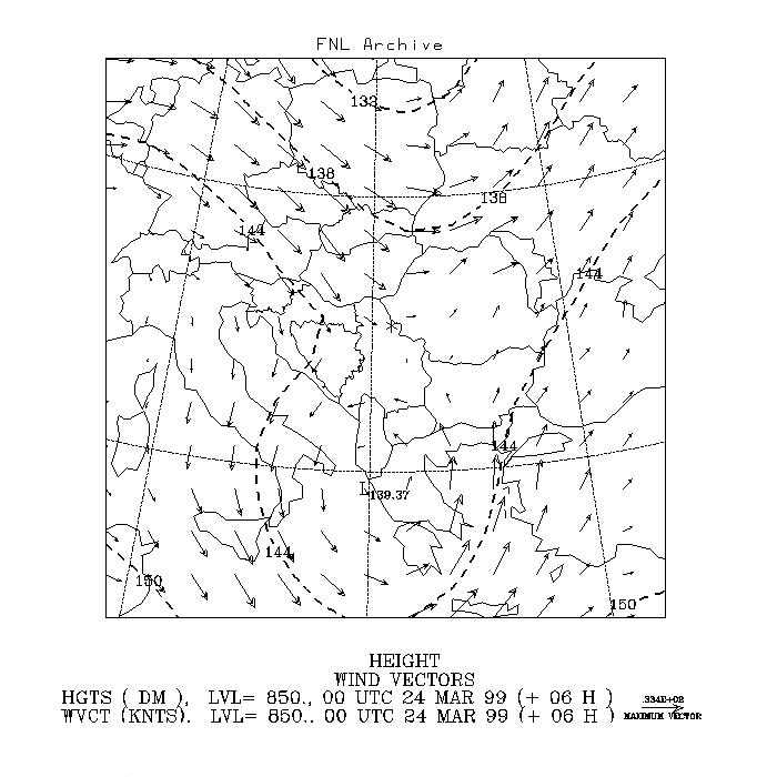
Figure 1
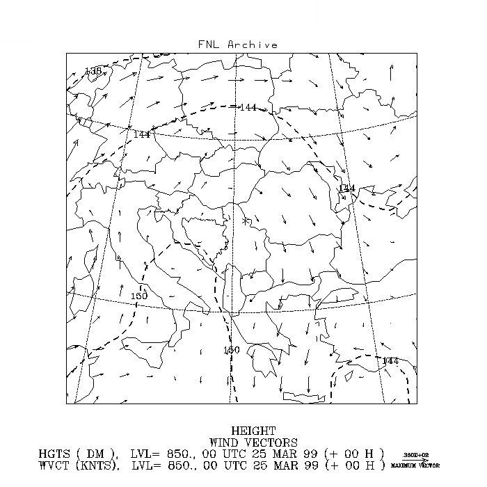
Figure 2
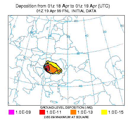
Figure 3
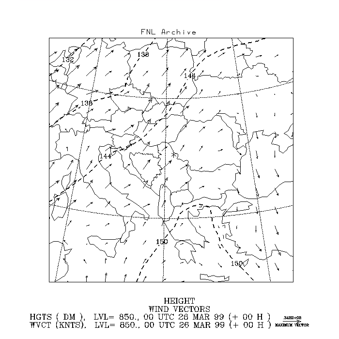
Figure 4
Figures. 1-4: Weather maps at 850 hPa for the period 24-27 March 1999. The maps are based on data from the GDAS and were produced on the NOAA Air Sources Laboratory's web site
On the 25th the oil in smeltery caught fire: 1000 kg of oil were burned and plastic thermic isolation caught fire and roof plastic glass were burned for all day. Black smoke wrapped the factory, obstracting road traffic towards Opovo and Kovacica, to the north of Pancevo. On the 27/3 the factory was hit and plastic products burned out completely.
Figs 1,2,3 and 4 show the wind vectors as they blew at the beginning of each day (midnight of 24, 25, 26, and 27 March 1999 at a height of about 1500 m above sea level). The first smoke plumes from that event passed over south Romania and dispersed. Only on the 25/3 a minor transport occurred to the southern parts of FRY. Rain on the 28th removed rapidly the airborne toxic smoke, depositing it to the ground (Fig 5). On the 25/3 the burning of fuel storage at Lipovicą, caused a great fire in the forest (26/3) which did not last much
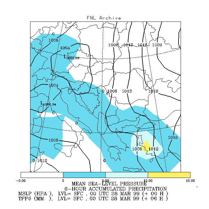
Figure 5: Weather map (6-hour accumulated precipitation) and pressure at SFC level for 28 March 1999. The map is based on data from the GDAS and was produced on the NOAA Air Sources Laboratory's web site (http://www.arl.noaa.gov/ready/hysplit4.html).
because of the weather conditions. In the following paragraph we study separately the period of the Pancevo bombardment 12-18/4 and the period of multiple sources of toxic emissions (4-7/4).
On April the 12th, the Pancevo NIS oil refinery was attacked for the second time (the first was on the 4/4 when 2,900 tons of gasoline and a few hundred tons of Diesel, jet-fuel and crude oil were burned). Air pollution measurements did not show any significant departures of air pollution at ground level, according to measurements of the Serbian authorities. The winds were from the west near the surface and northwest at 1500 m above sea level. A second attack at night produced above normal concentrations of hydrocarbons, according to the official note of the Republic of Serbia on 16/6/1999. Air pollutants remained inside their allowable limits through 15/4.
According to official reports from the plants and from the Serbian Government the ammonia III Plant of "HIP Fertilizers" and HIP Petrochemicals were hit. About 1400 tons of ethylene dichloride poured out through the drainage into the Danube. All installations have been stopped while the remaining gas was speedily burned on the Flares producing black smoke. The wind blew towards Danube and the Tamis rivers.
Catalytic retorts, accessory reservoirs and electric installations were damaged. On the 16/4 the oil refinery was hit again. On the 18/4 at 1:00 am the installations for VCM and PVC production were hit. A spherical reservoir with 1200 tons of VCM was destroyed and 6 train cisterns of 30 tons of VCM each. All VCM contents in the reservoir burned out for several hours. The direction of near surface wind was at 140° ± 20° with periodical gusts of poisonous cloud in the parts of the city near the Tamis river.
The upper winds at 1500 m above sea level were from WSW directions as can be seen from Fig. 6. Measurements of the City Institute for Health Protection have shown the following:
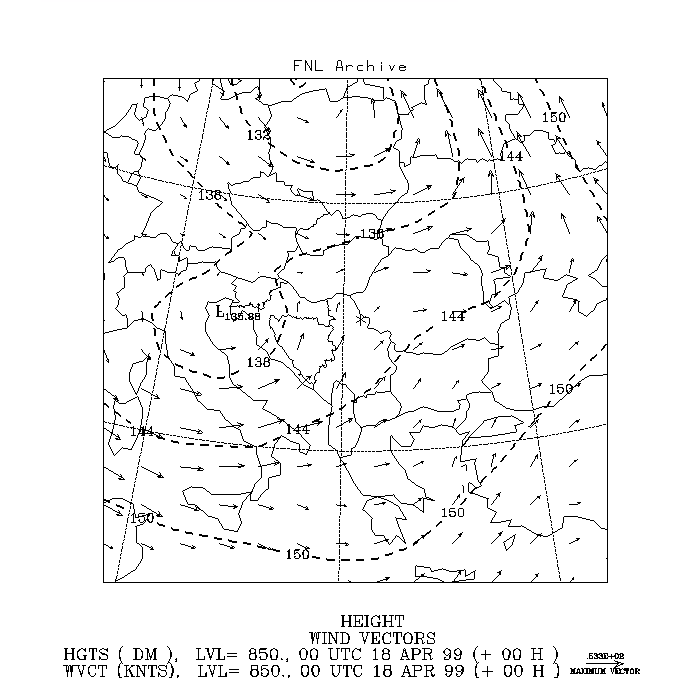
Figure 6: Weather map at 850 hPa for 18 April 1999. The map was produced on the NOAA Air Sources Laboratory's web site (http://www.arl.noaa.gov/ready/hysplit4.html).
The VCM concentration early in the morning was 0,36 mgm-3 (360,000 nanograms/m-3 ) which compared to the allowable limits of 50ngr/m3 is 7200 times in excess of the allowed values. The measuring point is called the Firebrigade station. By mid-day the VCM concentration has rosen to 530,000 ngr/m-3. After reaching a peak, VCM values dropped, because of the change of the wind, to 0,1 mgr/m-3. Except for the VCM, other air pollutants did not exceed their allowable values according to the Serbian report.
During the event of the 18/4, a large quantity of raw material for NPK fertilizers was destroyed as water was used to extinguish the fire. After the strike of the ammonia III plant and of the factory for the production of NPK fertilizers, large quantities of ammonia, nitric acid, naphta and other dangerous substances were poured out in air, water and soil. As a result of the rainy days which followed, black and "coloured" rain occurred in all surrounding villages in Serbia and southwestern Romania.
Dispersion calculations for the period 17-19 April 1999 that were carried out with the Langrangian modeling system. HYSPLIT_4 (Hybrid Single –Particle Langrangian Integrated Trajectory) (HYSPLIT4, 1997, Draxler, 1997, Draxler, 1998) confirm significant transboundary transport in the region to the NE of Pancevo. The gridded meteorological data required for the application of the model, were obtained from the National Weather Service’s National Centers for Environmental Prediction (NCEP) of USA. The operational system used to produce these data is the Global Data Assimilation System (GDAS) (Kanamitsu, 1989), which uses the spectral Medium Range Forecast model (MRF) for the forecast (Sela, 1980). The data are converted from the 1 degree latitude-longitude original grid to hemispheric 129 by 129 polar stereographic grids and are archived for 4 times a day i.e. at 00, 06, 12, and 18 UTC. The upper level data are output on the following mandatory pressure surfaces: 1000, 925, 850, 700, 500, 400, 300, 250, 200, 150, 100, 50 and 20 hPa. Since the exact emission rate is not known, calculations were performed by assuming an emission of 1 unit of pollutant per hour. The combination of the information about the bombing found in the internet with estimations about emissions from the Serbian reports and from explosions found in the literature (Church, 1969) resulted to the following emission scenario for April 17-19, 1999:
April 17 – 19: One line source from 100m to 500m AGL over Pancevo. The emission started at April 18, 01:00 L.T. and lasted for 24 hours.
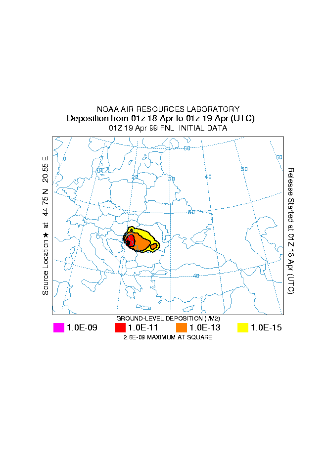
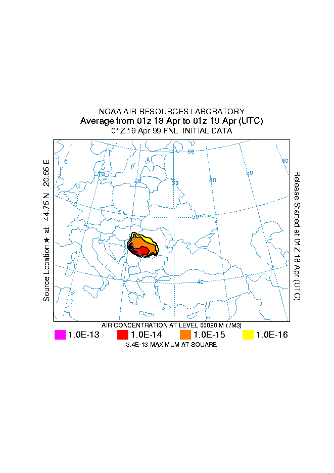
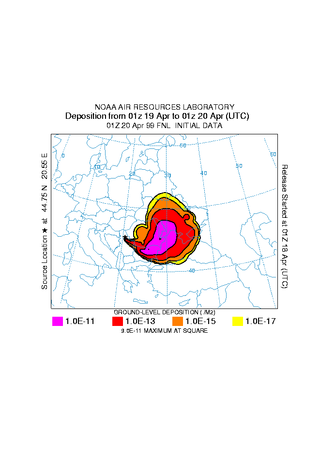

Figure 7: Time integrated deposition calculated with HYSPLIT_4 modelling system. The star indicates the geographic position of the source. A line source is assumed which streches from 100 to 500 m AGL. The concentrations are given in relative units, corresponding to an emission rate of 1unit of pollutant per hour.
The time-integrated concentrations and deposition rates from the above dispersion calculations are shown in figure 7. From that figure it appears that during the Pancevo incident of 17 –19 April, large amounts of airborne toxic gases and aerosols are estimated to have been transported and deposited in Romania and, to a lesser extent, in Bulgaria, Moldavia and Ukraine. Calculations show that it is not surprising that air pollutants in the Pancevo area did not exceed the allowable limits (except for the VCM) since they seem to have been transported to larger distances from their source at higher elevations.